Unit 03 · Sedimentary Rocks & Stratigraphy
Sedimentary rock is Earth's field notebook — weathered fragments and dissolved minerals buried, compacted, and cemented into layers that record the environments that made them. This unit covers clastic rocks like sandstone, shale, and conglomerate, chemical rocks like limestone and rock salt, and organic rock like coal, then turns to the stratigraphic principles — superposition, original horizontality, lateral continuity, and cross-cutting relationships — that let you read a stack of beds as a sequence of time. Mastery means you can name a rock, name the environment that deposited it, and order a cliff face from oldest to youngest.
Student learning: Read a stratigraphic column and distinguish thickness from elapsed time
Choose the level by readiness, not age alone, and record it before instruction. Foundation, core, and honors tasks are study pathways, not an AP course or a promise of college credit. The instructor retains practical assessment and the published science rubric; integration is reported separately.
Prerequisites: Rock families, lengths and scale, percentages, and the distinction between relative order and numerical age.
Suggested sequence: read and discuss the explanation; attempt the worked model; analyze the data at your selected level; check the answers; then complete the source-linked response and a fresh transfer question. These activities supplement, not replace, supervised practical work and the full-year schedule.
Assigned reading and focus
- Physical Geology 2e, 6.3: Depositional Environments and Sedimentary Basins. Compare the illustrated environments and the role of preservation in basins. A deposited sediment need not survive to become rock.
- Physical Geology 2e, 8.2: Relative Dating Methods. Read superposition, inclusions, cross-cutting, and unconformities. Use the figures to separate observed relationships from a presumed complete sequence.
Learn the science
Superposition orders an undisturbed upright sedimentary sequence; overturned beds and faults require additional interpretation. Grain size, sorting, structures, and fossils constrain environment, but one rock name alone does not prove a unique setting.
The log below uses height upward from an arbitrary base. Bed thickness is top minus bottom. A scale drawing must state its orientation and distinguish thickness from elevation above sea level.
Preserved thickness divided by a supplied duration is an average net accumulation model. Compaction, erosion, a hiatus, and changing deposition can make it very different from gross deposition or an instantaneous rate.
Cross-cutting and truncation can establish order without a numerical duration. An unconformity identifies missing or unrecorded time; its appearance alone does not reveal how long the gap lasted.

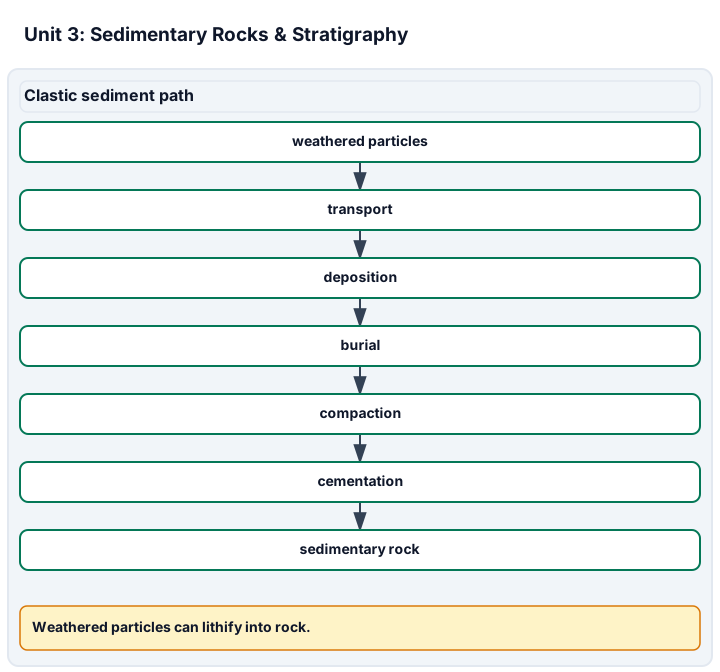
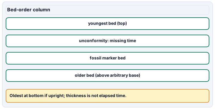
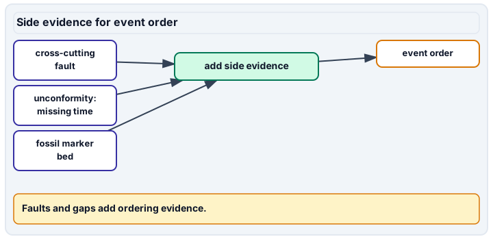
Diagram description
The first panel shows clastic weathered particles moving through transport, deposition, burial, compaction and cementation to sedimentary rock; chemical dissolved ions and organic plant remains also feed deposition. The bed-order column lists the youngest bed at the top, then a missing-time unconformity, a fossil marker bed and the older bed above an arbitrary base, with no arrows; the side-evidence panel adds a cross-cutting fault, the unconformity and the fossil marker bed to event-order reasoning. Thickness is computed from top and base heights measured from the arbitrary base level.
Data, provenance, and assumptions
| Bed | Base height (m) | Top height (m) | Supplied description |
|---|---|---|---|
| A | 0 | 12 | Sandstone |
| B | 12 | 20 | Mudstone |
| C | 20 | 25 | Limestone |
| Preserved thickness (m) | Duration (thousand years) |
|---|---|
| 8 | 160 |
| Observation | Relationship supported |
|---|---|
| A is overlain by B in an upright sequence | A predates B |
| A and B are tilted and truncated | Tilting and erosion follow B |
| Horizontal C rests on the truncation surface | C follows the erosion |
| Fault F cuts A, B, and C; cap D is not cut | F follows C and predates D in this stated model |
Worked model
The log has bed thicknesses 12, 8, and 5 m, totaling 25 m. Mudstone accounts for 8/25 = 32%. At 1 cm per 5 m, the full drawn column is 5 cm tall. The separate accumulation model gives 8/160 = 0.05 mm/year.
Numerical calibration
- 25 m
- 32 percent of preserved thickness
- 5 cm at the assigned scale
- 0.05 mm/year under the model
Attempt the assigned level
Try the tasks before reading the calibration. These are practice answers, not a secure examination; use a new dataset or changed assumption for the assessed transfer.
Foundation
- Draw the column to scale and order A, B, and C from oldest to youngest under the stated assumptions.
- Explain one observation that could invalidate simple superposition.
Check after your attempt
- A is oldest, then B, then C. The drawing is 5 cm high at the stated scale.
- Overturning, a fault, or reworked fragments could require a different interpretation; state which observation supports the concern.
High-school core: typically grades 9-10
- Compute bed thicknesses, mudstone percentage, and the separate preserved accumulation rate.
- Order the events in the evidence table and distinguish the erosional surface from a measured duration.
Check after your attempt
- 12, 8, and 5 m; 32%; 0.05 mm/year under the given model.
- A, B, tilting, erosion, C, fault F, then D. The data supply no numerical length for the erosional gap.
Honors extension: typically grades 11-12
- Explain how compaction or a hiatus changes the interpretation of the 0.05 mm/year average.
- Propose independent evidence that could constrain a missing interval rather than assigning time from bed thickness alone.
Check after your attempt
- The value is net preserved thickness per supplied duration. Gross deposition may have been faster and intermittent; lost thickness or time changes the inference.
- Appropriately interpreted dated ash beds, detrital grains, fossil correlations, or other mapped relations can provide bounds, with their assumptions.
History, reading, and writing connection
Connect the relative-dating reading to the diagram you constructed. Explain why early geological ordering could be useful before numerical ages were available, and identify the limits of your reconstructed history.
Write in your own words or use an approved accessible equivalent. Cite a specific assigned section or figure, identify its evidence, and state one limitation or counterargument. Use the AI practice contract only for permitted coaching, never to invent observations or write the assessed response.
Transfer to a new case
A new observation shows the beds are overturned. Can the original oldest-to-youngest order be retained automatically?
Calibration: No. Reassess orientation and structural evidence before applying the upright-sequence rule.
Evidence to retain
Submit the scaled log, calculations, event-order argument, and a limitation. A drawing from supplied data is not a field measurement or a dated outcrop.
Record units, calculations, source/date, uncertainty, and what is measured versus inferred. A simulation or supplied dataset must stay labeled as such. Use supplied data, approved photographs, or the non-destructive observation plan. No hammering, acids, excavation, water sampling, unstable-site entry, or engineering/safety clearance is authorized by these lessons.
Return to all eight learning pathways. Print this unit page for the student lessons; the linked five-page packet remains the separate assessment companion.
Unit mastery rubric
| Criterion | Developing | Proficient | Mastery |
|---|---|---|---|
| Sediment to rock: compaction & cementation | Cannot describe how loose sediment becomes rock. | Names compaction or cementation but not both, and not in order. | Traces weathered sediment through burial, compaction, and cementation into solid rock. |
| Clastic, chemical & organic rocks | Groups all sedimentary rock together. | Sorts a few rocks but confuses the three origins. | Classifies sandstone, shale, limestone, rock salt, and coal by clastic, chemical, or organic origin. |
| Depositional environment | Cannot connect observations to an environment. | Uses one property as a unique environmental diagnosis. | Combines grain size, sorting, structures, and composition to compare plausible depositional environments and their limits. |
| Stratigraphic principles | Cannot order the supplied relationships. | Applies superposition without checking orientation or disturbance. | Uses appropriate relative-dating principles, a scaled log, and stated structural assumptions to order events and calculate thicknesses. |
| Unconformities & preserved accumulation | Treats the record as complete and uniform. | Identifies a gap but assigns its duration without evidence. | Explains erosion/non-deposition, calculates assigned preserved rates, and identifies effects of compaction, hiatuses, and missing records. |
| Integration (cross-domain) | Makes no supported connection between the source and the science. | Uses the source but needs help connecting evidence, writing, or limitations to the science. | Independently connects History, Reading, and Writing using a cited source, appropriate evidence, a limitation, and a scientific explanation. |
Integration is reported separately and cannot lower the science grade or block a science demonstration pass. Science and practical criteria determine that pass. Use the integration guide's evidence checklist for the separately reported criterion.
“Sorting and structures help constrain an environment, but a sandstone name alone does not prove a beach. In the stated upright sequence, superposition orders the beds. The truncation shows an interruption; I need additional evidence to assign its duration.”
“It’s just striped rock. The layers are however old. I don’t know why there’s a gap in the middle.”
You demonstrate this unit at the specimen bench and with a stratigraphic column — identifying sedimentary rocks, reading their depositional environments, and ordering a set of beds by the stratigraphic principles aloud — not a multiple-choice test. A criterion counts as mastered only when you can both name the rock and defend the sequence of time it records. Mastery is demonstrated, not awarded.
A 5-page clipboard packet — unit overview, key terms, the mastery rubric, anchor examples, and a score sheet you can print and grade against.