Unit 05 · Plate Tectonics & Mountain Building
Earth’s outer shell is broken into slabs that grind past, pull apart from, and dive beneath one another. This unit covers the three boundary types — divergent, convergent, and transform — the seafloor spreading that widens ocean basins and the subduction that consumes them, the engine that drives it all (mantle convection, ridge push, and slab pull), and orogeny: the folding, faulting, and uplift that raise a mountain belt. Mastery means you can read a boundary from its features, predict the landforms and hazards it produces, and trace how a range is built.
Student learning: Separate relative motion, boundary opening, and net uplift
Choose the level by readiness, not age alone, and record it before instruction. Foundation, core, and honors tasks are study pathways, not an AP course or a promise of college credit. The instructor retains practical assessment and the published science rubric; integration is reported separately.
Prerequisites: Coordinate differences, time intervals, centimeters/meters/kilometers, and vector magnitude for core/honors work.
Suggested sequence: read and discuss the explanation; attempt the worked model; analyze the data at your selected level; check the answers; then complete the source-linked response and a fresh transfer question. These activities supplement, not replace, supervised practical work and the full-year schedule.
Assigned reading and focus
- USGS: Understanding Plate Motions. Read divergent, convergent, transform, and broad boundary-zone descriptions. Treat the historical examples as context, not as current site-specific rate measurements.
Learn the science
Plate motion is relative to a stated frame. Motion across a boundary and motion along it are components, not necessarily the whole relative speed. A magnitude alone does not determine boundary type without orientation.
The supplied local coordinate system has east as x and north as y, with readings ten years apart. The model boundary runs north-south, so relative eastward movement is opening and relative northward movement is along-boundary motion.
A short modern rate extrapolated over millions of years produces a model timescale, not a measured age. Rates, directions, and boundary configurations change; use geological evidence before reconstructing an ocean or mountain history.
Horizontal plate convergence is not itself a vertical uplift rate. Surface elevation reflects uplift, erosion, subsidence, and episodic processes. The separate uplift exercise states simple constant rates solely for arithmetic.

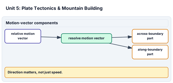
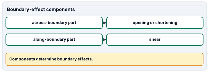
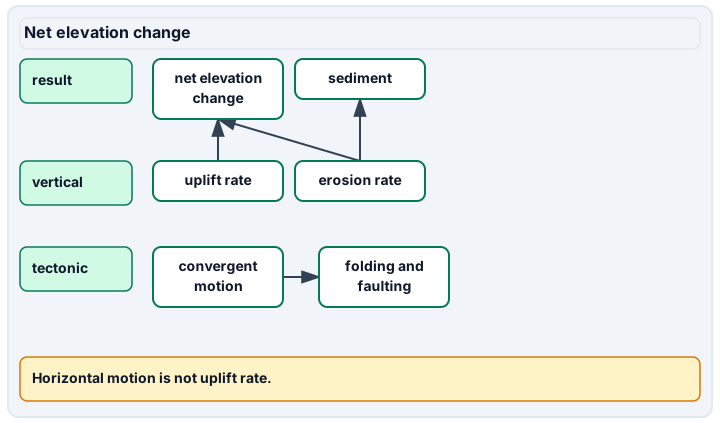
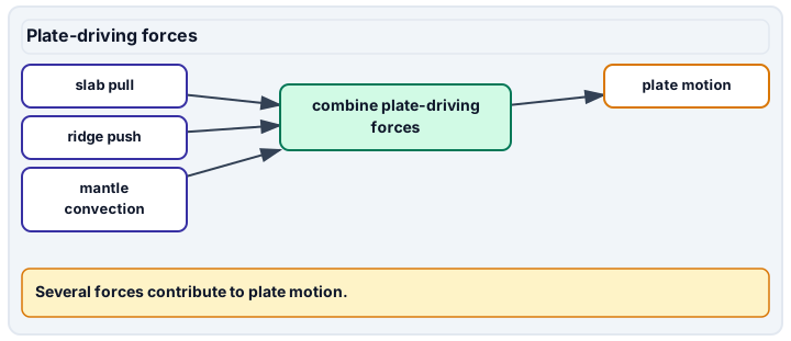
Diagram description
Relative motion is split into across-boundary and along-boundary components; the across-boundary part gives opening or shortening and the along-boundary part gives shear. Net elevation change depends on uplift adding elevation and erosion subtracting elevation over time; convergent motion can fold and fault rock but is not itself vertical uplift. Slab pull, ridge push and mantle convection are listed as contributors to plate motion.
Data, provenance, and assumptions
| Station | Initial east (m) | Initial north (m) | East after 10 years (m) | North after 10 years (m) |
|---|---|---|---|---|
| A | 0 | 0 | 0.2 | 0 |
| B | 100 | 0 | 100.5 | 0.4 |
| Uplift (mm/year) | Erosion (mm/year) | Duration (years) |
|---|---|---|
| 4 | 3 | 10000 |
Worked model
A moves 2 cm/year east. B moves 5 cm/year east and 4 cm/year north, so B relative to A is 3 east and 4 north: a speed of 5 cm/year. Only the 3 cm/year normal component opens this north-south boundary.
Numerical calibration
- 3 cm/year
- 4 cm/year
- 5 cm/year
- 33.33 million years under constant opening
- 10 m
Attempt the assigned level
Try the tasks before reading the calibration. These are practice answers, not a secure examination; use a new dataset or changed assumption for the assessed transfer.
Foundation
- Compute the eastward rates of A and B and identify which changes more.
- Calculate net elevation change from the separate uplift and erosion rates.
Check after your attempt
- A: 2 cm/year; B: 5 cm/year east.
- Net gain is 1 mm/year, producing 10 m over 10,000 years in the stated model.
High-school core: typically grades 9-10
- Calculate relative east and north components and total relative speed.
- Distinguish the opening component from along-boundary motion and vertical uplift.
Check after your attempt
- Relative components are 3 and 4 cm/year; total speed is 5 cm/year.
- Opening is the normal east component, 3 cm/year. North motion is along the boundary; neither is the supplied vertical uplift rate.
Honors extension: typically grades 11-12
- Estimate how long 1000 km of opening would take at the constant normal rate.
- Give an opening-time range if that rate were 2-4 cm/year, and explain why the calculation is not a measured age.
Check after your attempt
- About 33.33 million years at 3 cm/year.
- The model range is 25-50 million years. A ten-year record does not establish constancy throughout that interval.
History, reading, and writing connection
Use the boundary reading to interpret the vector components. Explain which observations would test a long-term reconstruction and why a modern measurement and a geological history are not interchangeable.
Write in your own words or use an approved accessible equivalent. Cite a specific assigned section or figure, identify its evidence, and state one limitation or counterargument. Use the AI practice contract only for permitted coaching, never to invent observations or write the assessed response.
Transfer to a new case
Rotate the model boundary to east-west. Which component is now normal to it?
Calibration: The north component, 4 cm/year. Boundary orientation changes the opening interpretation even though the relative vector is unchanged.
Evidence to retain
Submit a coordinate sketch, rate/vector work, and the explicit timescale assumptions. The exercise does not forecast an earthquake or establish a safe building location.
Record units, calculations, source/date, uncertainty, and what is measured versus inferred. A simulation or supplied dataset must stay labeled as such. Use supplied data, approved photographs, or the non-destructive observation plan. No hammering, acids, excavation, water sampling, unstable-site entry, or engineering/safety clearance is authorized by these lessons.
Return to all eight learning pathways. Print this unit page for the student lessons; the linked five-page packet remains the separate assessment companion.
Unit mastery rubric
| Criterion | Developing | Proficient | Mastery |
|---|---|---|---|
| Plate boundaries & their features | Cannot tell divergent, convergent, and transform boundaries apart. | Names the three boundary types but misreads which features mark each. | Classifies a boundary from its landforms, earthquakes, and volcanism, distinguishing divergent, convergent, and transform. |
| Seafloor spreading & subduction | Treats the ocean floor as fixed and ageless. | Describes spreading or subduction but not how they balance. | Explains how new crust forms at ridges and old crust returns at trenches, using seafloor age and magnetic stripes as evidence. |
| The driving engine | Says plates move but cannot say why. | Names mantle convection but omits ridge push and slab pull. | Explains plate motion through mantle convection, ridge push, and slab pull, and weighs their relative roles. |
| Orogeny & mountain building | Equates horizontal convergence with vertical mountain growth. | Names uplift but omits erosion or structural context. | Explains folding, faulting, and uplift; evaluates assigned net-elevation models without equating convergence with vertical growth. |
| Plate-boundary maps & relative motion | Cannot orient the map or compare station positions. | Calculates speed but ignores direction or boundary orientation. | Uses map evidence and relative vectors to distinguish normal and along-boundary motion, with units and limits on extrapolated timescales. |
| Integration (cross-domain) | Makes no supported connection between the source and the science. | Uses the source but needs help connecting evidence, writing, or limitations to the science. | Independently connects History, Reading, and Writing using a cited source, appropriate evidence, a limitation, and a scientific explanation. |
Integration is reported separately and cannot lower the science grade or block a science demonstration pass. Science and practical criteria determine that pass. Use the integration guide's evidence checklist for the separately reported criterion.
“This deep band of earthquakes plunging under the trench tells me it’s a convergent boundary with subduction — that’s why there’s a volcanic arc behind it. The slab is being pulled down by slab pull, not shoved by the continent.”
“The plates just move around. This is where two of them meet, and mountains happen because they crash. I’m not sure what makes them move.”
You demonstrate this unit by modeling a plate boundary from a seismic and volcanic map — classifying it, predicting its landforms and hazards, and tracing how it builds or destroys crust aloud, not on a multiple-choice test. A criterion counts as mastered only when your boundary call matches the map evidence and you can justify the driving forces behind it. Mastery is demonstrated, not awarded.
A 5-page clipboard packet — unit overview, key terms, the mastery rubric, anchor examples, and a score sheet you can print and grade against.