Unit 03 · Weathering, Erosion & Soil
This unit follows rock as it comes apart and moves: physical weathering that breaks rock without changing it and chemical weathering that rots it from the inside, erosion that carries the pieces away, deposition that lays them down, and the soil horizons that build slowly where all of this comes to rest. Mastery means you can read a landscape as a balance of weathering, transport, and deposition — a surface always being remade, not a fixed backdrop.
Student learning: Quantify landscape gradient, sediment transport and soil horizons
Choose the level by readiness, not age alone, and record it before instruction. Foundation, core, and honors tasks are study pathways, not an AP course or a promise of college credit. The instructor retains practical assessment and the published science rubric; integration is reported separately.
Prerequisites: Foundation: differences and part/whole fractions. Core: dimensional analysis, mg-to-g and seconds-to-hours conversions. Honors: inverse tangent in degree mode and products of bounded quantities. Readiness check: 0.5 m^3/s is 500 L/s; a 20 m fall over 500 m is a ratio of 0.04, not 20%. Start with foundation if these conversions need support.
Suggested sequence: read and discuss the explanation; attempt the worked model; analyze the data at your selected level; check the answers; then complete the source-linked response and a fresh transfer question. These activities supplement, not replace, supervised practical work and the full-year schedule.
Assigned reading and focus
- Steven Earle, Physical Geology 2e, 13.3: Stream Erosion and Deposition. Read the velocity profile and sediment-transport descriptions. Distinguish bed, suspended and dissolved load, and do not equate every transported particle with local erosion.
- Steven Earle, Physical Geology 2e, 5.4: Weathering and the Formation of Soil. Read soil-forming factors and soil horizons. The supplied profile is one teaching case, not a universal soil-depth pattern or an instruction to excavate.
Learn the science
Percent gradient = vertical fall/horizontal distance x 100. It is a ratio, not an angle. The angle of the idealized slope is arctan(fall/run); use degree mode when reporting degrees.
For uniform supplied discharge Q and suspended concentration C, suspended mass flux is Q x C after reconciling volume units. 1 m^3 = 1000 L, and 1000 mg = 1 g. This excludes bed load and dissolved load.
A larger downstream suspended flux is not automatically the rate of local erosion: incoming sediment, temporary storage and remobilization also matter. The two cases below do not isolate flow as the only causal variable because concentration also changes.
Horizon thickness fraction uses the total stated profile thickness as its denominator. Horizon thicknesses are not equal to soil mineral, organic, air or water composition fractions, and do not by themselves date soil formation.

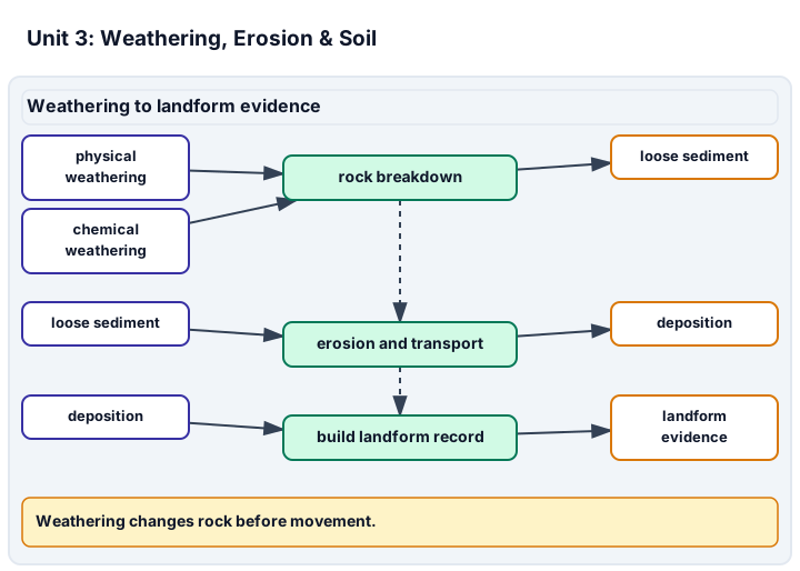
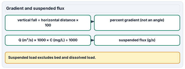
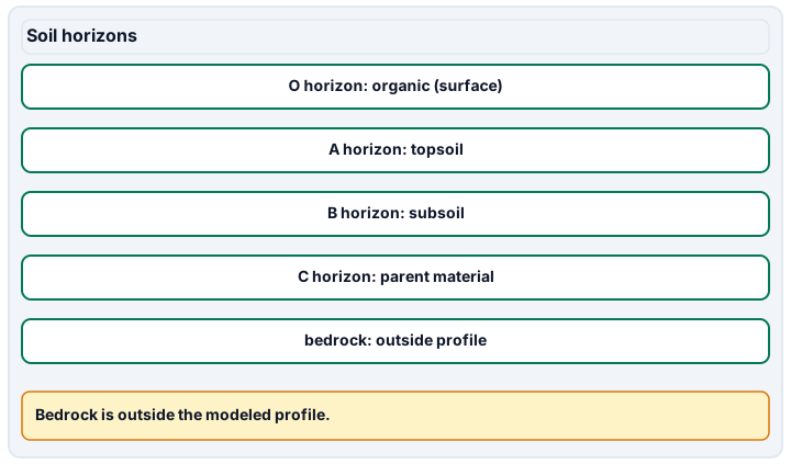
Diagram description
Weathering is split into physical and chemical routes that create loose sediment; sediment can be eroded, transported and deposited to build landform evidence, while chemical weathering can also create landform evidence such as karst. Two separate formula rows give percent gradient (a ratio, not an angle) and suspended flux in grams per second after unit conversions. Soil horizons O, A, B and C are listed from the surface down, above bedrock, which is outside the modeled profile; no arrows join the horizons.
Data, provenance, and assumptions
| Horizontal position (m) | Elevation (m) |
|---|---|
| 0 | 120 |
| 250 | 110 |
| 500 | 100 |
| Case | Discharge (m^3/s) | Suspended concentration (mg/L) |
|---|---|---|
| Low | 0.2 | 25 |
| High | 0.5 | 80 |
| Horizon | Thickness (cm) |
|---|---|
| O | 2 |
| A | 18 |
| B | 30 |
| C | 50 |
Worked model
The transect falls 20 m over 500 m horizontally: 20/500 x 100 = 4%. In the Low transport case, 0.2 m^3/s x 1000 L/m^3 x 25 mg/L = 5000 mg/s = 5 g/s. Over one hour, 5 x 3600/1000 = 18 kg of suspended sediment passes the section; that is not a measurement of local soil loss.
Numerical calibration
- 4 % gradient
- 2.2906 degrees, ideal straight slope
- 5 g/s suspended flux
- 40 g/s suspended flux
- 18 kg transported in one hour
- 144 kg transported in one hour
- 18 % of profile thickness
Attempt the assigned level
Try the tasks before reading the calibration. These are practice answers, not a secure examination; use a new dataset or changed assumption for the assessed transfer.
Foundation: typically grades 7-8
- Calculate the percent gradient and the map length of 500 m on a 1:25,000 map.
- Find each horizon's proportion of the whole stated profile and identify the denominator.
Check after your attempt
- Gradient is 4%. Convert 500 m to 50,000 cm, then divide by 25,000: the map length is 2 cm.
- The denominator is 100 cm. O is 2%, A 18%, B 30%, and C 50% of profile thickness, not chemical composition.
High-school core: typically grades 9-10
- Calculate the suspended flux in g/s and one-hour mass in kg for both cases. Compare the flux ratio with the discharge ratio.
- Use the profile and reading to explain why neither the A-horizon thickness nor the passing sediment alone gives an erosion rate at the transect.
Check after your attempt
- Low: 5 g/s and 18 kg/hour. High: 40 g/s and 144 kg/hour. Flux rises eightfold, while discharge rises 2.5-fold and concentration 3.2-fold.
- A soil-loss rate needs repeated measurements, area and time context, and sediment inputs/storage. Thickness also reflects formation and past change; passing sediment may have come from upstream.
Honors extension: typically grades 11-12
- Calculate the slope angle in degrees and explain why a 4% grade is not a 4-degree slope.
- Use the High case bounds to find minimum and maximum suspended flux. Describe a matched comparison needed to isolate the influence of discharge.
Check after your attempt
- arctan(0.04) = about 2.291 degrees. Percent grade and angle are different representations linked nonlinearly.
- Minimum: 0.45 x 72 = 32.4 g/s; maximum: 0.55 x 88 = 48.4 g/s. These are endpoint bounds, not a confidence interval. Hold sediment supply, geometry and other conditions comparable before attributing a difference to discharge.
History, reading, and writing connection
Use the named soil and transport sections to write an evidence-based correction to the claim that every kilogram passing a stream section was eroded from the nearest field that day. Separate the measured quantity, the possible history and the extra observations needed.
Write in your own words or use an approved accessible equivalent. Cite a specific assigned section or figure, identify its evidence, and state one limitation or counterargument. Use the AI practice contract only for permitted coaching, never to invent observations or write the assessed response.
Transfer to a new case
A new supplied reach falls 15 m in 600 m. Its steady discharge is 0.4 m^3/s with 50 mg/L suspended sediment. Foundation: find percent gradient. Core: find suspended flux. Honors: find the slope angle and mass passing in 30 minutes at that fixed flux. All levels: explain why transported sediment need not be local erosion.
Calibration: Foundation: 15/600 x 100 = 2.5%. Core: 0.4 x 1000 x 50/1000 = 20 g/s. Honors: arctan(0.025) = about 1.432 degrees; 20 x 1800/1000 = 36 kg passes in 30 minutes. Some sediment may originate upstream or come from stored deposits.
Evidence to retain
At the agreed level retain a scaled transect, horizon fractions, the selected flux or angle/bounds work, and transfer. These are evidence for the Transport quantities, Soil profile and Landscape gradient science criteria. Interpret the supplied model without claiming hands-on stream-table control. Sources checked 2026-09-27.
Record units, calculations, source/date, uncertainty, and what is measured versus inferred. A simulation or supplied dataset must stay labeled as such. No field exposure or weather chasing; no water sampling, ingestion, or chemical tests; no solar viewing. Use supplied data and approved images or non-destructive indoor alternatives only. A worksheet does not demonstrate practical performance or authorize a real location or safety forecast.
Return to all eight learning pathways. Print this unit page for the student lessons; the linked five-page packet remains the separate assessment companion.
Unit mastery rubric
| Criterion | Developing | Proficient | Mastery |
|---|---|---|---|
| Physical & chemical weathering | Cannot tell physical weathering from chemical, or thinks rock does not really change. | Names both kinds but cannot give an agent or example for each. | Distinguishes physical from chemical weathering, names the agent driving each, and predicts which dominates in a given climate. |
| Transport quantities | Confuses flow, concentration and mass flux. | Converts quantities with help but calls all transport local erosion. | At the agreed level, interprets or calculates supplied suspended flux, retaining units and the transport-versus-erosion distinction. |
| Soil profile | Cannot identify the profile denominator. | Calculates fractions but confuses thickness and composition. | At the agreed level, calculates horizon fractions and explains soil-forming factors without inferring age from thickness alone. |
| Landscape gradient | Confuses rise, run or scale. | Calculates a gradient but mislabels percent or angle. | At the agreed level, defends the scaled transect, percent gradient or slope angle and its model limits. |
| Model evaluation | Treats the supplied cases as a controlled field experiment. | Notices one changed variable but overlooks others. | Identifies changed variables, incoming sediment and missing controls; does not claim practical stream-table performance from data. |
| Integration (cross-domain) | Makes no supported connection between the source and the science. | Uses the source but needs help connecting evidence, writing, or limitations to the science. | Independently connects History, Reading, and Writing using a cited source, appropriate evidence, a limitation, and a scientific explanation. |
Integration is reported separately and cannot lower the science grade or block a science demonstration pass. Science and practical criteria determine that pass. Use the integration guide's evidence checklist for the separately reported criterion.
“The supplied fall/run is 20/500 = 4%, not 4 degrees. The High case transports 40 g/s, eight times the Low case, because both discharge and concentration change. This does not tell me how much soil eroded locally; incoming sediment and storage are missing.”
“The hills have always looked like that. Erosion is too slow to matter. Soil is just dirt.”
Submit the agreed level’s transect, horizon fractions and selected transport/bounds work, then defend the fresh transfer. Use supplied records or approved images; no field collection or excavation is required. A data interpretation is science evidence, not proof of hands-on stream-table control. Report integration separately.
A 5-page clipboard packet — unit overview, key terms, the mastery rubric, anchor examples, and a score sheet you can print and grade against.