Unit 07 · Weathering, Erosion & Landforms
Mountains do not last; they are taken apart grain by grain and rebuilt as new landscapes. This unit covers mechanical weathering — frost wedging and exfoliation that break rock without changing it — and chemical weathering — carbonate dissolution and karst, oxidation, and hydrolysis that alter it; the erosion and transport of that debris by water, wind, and glacial ice; the deposition that follows; and the signature landforms each agent carves, from meanders and deltas to dunes, moraines, and karst caves. Mastery means you can name the process from the landform and read a landscape as a record of the forces that shaped it.
Student learning: Trace groundwater, sediment flux, and landscape evidence safely
Choose the level by readiness, not age alone, and record it before instruction. Foundation, core, and honors tasks are study pathways, not an AP course or a promise of college credit. The instructor retains practical assessment and the published science rubric; integration is reported separately.
Prerequisites: Sedimentary structure, ratios, rates, area/volume units, and separating an observed feature from its inferred process.
Suggested sequence: read and discuss the explanation; attempt the worked model; analyze the data at your selected level; check the answers; then complete the source-linked response and a fresh transfer question. These activities supplement, not replace, supervised practical work and the full-year schedule.
Assigned reading and focus
- Physical Geology 2e, 14.1: Groundwater and Aquifers. Read porosity, permeability, and aquifers. Explain why high porosity need not mean rapid flow and why pore connectivity matters.
- Physical Geology 2e, 14.2: Groundwater Flow. Read water table/potentiometric surface and Darcy flow. Distinguish hydraulic head, discharge, Darcy flux, and average pore velocity. The digging/well examples are not student procedures.
- Physical Geology 2e, 13.3: Stream Erosion and Deposition. Read transport, discharge, suspended load, and deposition. An instantaneous concentration is not a complete daily sediment budget.
Learn the science
Weathering changes or breaks material in place; erosion and transport move it. Carbonate dissolution contributes to karst, but a fizz-test result alone does not establish a cave, sinkhole, or unsafe site. Similar landforms can have more than one plausible history.
Groundwater commonly occupies connected pores and fractures, not a universal underground river. Porosity is not hydraulic conductivity: storage space and ease of flow are different properties. Conductivity also depends on the fluid and conditions; effective porosity describes the connected space used in a flow model.
Water flows from higher to lower hydraulic head along available pathways, not necessarily parallel to ground-surface slope. Head includes elevation and pressure contributions; an artesian head is not the same as the top of an aquifer.
For this homogeneous saturated model, gradient i = head drop / distance, discharge Q = K i A, Darcy flux q = Q/A, and average pore velocity v = q/ne. The stated effective porosity ne is a fraction, not a percentage entered as 25.
A distance/v estimate is only an advective model timescale. Fractures, dispersion, sorption, pumping, and variable conditions can change transport; the calculation does not establish drinking-water safety or a contaminant arrival forecast.
Sediment mass rate combines concentration and discharge with compatible units. Multiplying one reading by a day is a hypothetical constant-rate model, not an actual daily load measurement. Integrate changing intervals when those data are available.

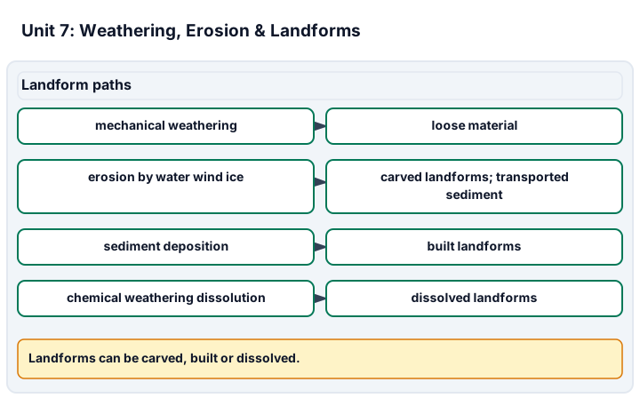
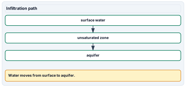
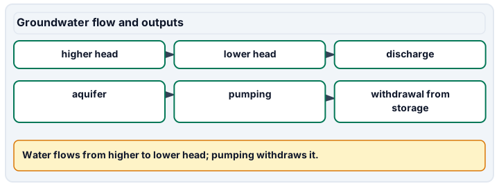
Diagram description
Mechanical weathering breaks rock into loose material without changing it; erosion by water, wind or ice carves landforms and carries material away as transported sediment; deposition of that sediment builds landforms; and chemical weathering can dissolve rock into landforms such as karst. Groundwater infiltrates from surface water through the unsaturated zone to the aquifer; water flows from higher to lower hydraulic head and discharges, while pumping withdraws water from aquifer storage.
Data, provenance, and assumptions
| Distance along transect (m) | Hydraulic head (m) |
|---|---|
| 0 | 104 |
| 100 | 103 |
| 200 | 102 |
| K (m/day) | Cross-sectional area (m^2) | Effective porosity (fraction) |
|---|---|---|
| 10 | 20 | 0.25 |
| Discharge (m^3/s) | Suspended concentration (mg/L) |
|---|---|
| 0.5 | 20 |
| Discharge (m^3/s) | Suspended concentration (mg/L) | Interval (hours) |
|---|---|---|
| 0.2 | 10 | 6 |
| 0.5 | 20 | 6 |
| 1 | 40 | 6 |
| 0.3 | 15 | 6 |
Two-visit non-destructive landscape observation
Scope and safety: Use an instructor-approved level public path, a known safe display specimen, or approved photographs as the alternative. No hammering, scratching, acids, or excavation. No wading or entry into wells, caves, road cuts, quarries, unstable slopes, or damaged areas. Do not collect or handle unknown fibrous, dusty, or radioactive material. Follow access rules and adult supervision; stop for unsafe weather or conditions. These observations are not an engineering or site-safety assessment.
Materials and preparation
- Notebook, pencil, metric ruler used only where safely accessible, and an approved map or photograph with scale.
- An approved observation location and route, or a dated source-image pair. Do not record private addresses or identifying people in shared work.
- The instructor defines the visible feature, observation positions, and what may be measured without leaving the safe route.
Procedure and schedule
- Before the first visit, define the question and the approved route or image set. Assign an observation ID to each of three accessible views or reference frames.
- At the first of two visits, record date, evidence source, orientation, scale, and what is directly visible: layering, fractures, grain features, surface deposits, or vegetation cover. Keep inference in a separate column.
- Sketch the relationships from the safe position. Record a measurement only if the reference and scale are clear and accessible; do not approach a hazard to obtain it.
- At the second visit, ideally about a week later under safe conditions, repeat the same views and record weather/context and any change. No visible change is a valid result; short observations do not imply zero long-term erosion.
- Record missing views or uncertain scales explicitly rather than reconstructing an observation from memory. A photograph-based analysis remains labeled as supplied-image work.
- Compare the records, propose at least two interpretations when the evidence permits, and identify an additional observation that would discriminate between them without an unsafe excursion.
Record: Retain observation ID, date, source/location code, orientation, scale/units, direct description, measurement uncertainty, interpretation, and missing-data reason. The instructor assesses actual observation technique separately from a supplied-data analysis.
Worked model
The head gradient is (104-102)/200 = 0.010. Q = 10 times 0.010 times 20 = 2 m^3/day; q = 0.10 m/day and v = 0.10/0.25 = 0.40 m/day. The 200 m advective timescale is 500 days. The separate constant sediment example gives 0.010 kg/s, or 864 kg/day if sustained for 24 hours.
Numerical calibration
- 0.01 m/m
- 2 m^3/day
- 0.4 m/day
- 500 days, model only
- 864 kg/day if sustained
- 1220.4 kg in the modeled day
Attempt the assigned level
Try the tasks before reading the calibration. These are practice answers, not a secure examination; use a new dataset or changed assumption for the assessed transfer.
Foundation
- Draw the head transect and indicate the modeled direction of groundwater flow.
- Distinguish pore storage from flow ease and weathering from transport using the assigned figures.
Check after your attempt
- Head decreases from the 0 m end toward the 200 m end; flow tends in that direction under the stated connected model.
- Porosity concerns space; conductivity concerns flow under specified conditions. Weathering acts in place; erosion/transport move material.
High-school core: typically grades 9-10
- Calculate gradient, discharge, pore speed, and the advective timescale.
- Convert the momentary sediment measurement to a hypothetical constant daily mass and state why it is not an actual daily total.
Check after your attempt
- Gradient 0.010; discharge 2 m^3/day; pore speed 0.40 m/day; model time 500 days.
- 864 kg/day if sustained. Actual flow and concentration vary, and other load components may be omitted.
Honors extension: typically grades 11-12
- Integrate the four six-hour suspended-load intervals with consistent units.
- Halve effective porosity while keeping Darcy flux fixed, and explain the model change without asserting a real contamination forecast.
Check after your attempt
- The piecewise-constant estimate is 1220.4 kg for the modeled day.
- Pore speed doubles to 0.80 m/day and the model time halves to 250 days. This holds only for the stated flow model and unchanged flux.
History, reading, and writing connection
Cite the assigned groundwater and stream figures to explain why a landscape impression is not enough to calculate a flux or declare water safe. Compare the model assumptions with the evidence an actual investigation would need.
Write in your own words or use an approved accessible equivalent. Cite a specific assigned section or figure, identify its evidence, and state one limitation or counterargument. Use the AI practice contract only for permitted coaching, never to invent observations or write the assessed response.
Transfer to a new case
The land surface slopes east, but connected-aquifer head decreases west. Which direction controls the model flow?
Calibration: The hydraulic-head gradient, not surface slope alone. Verify the common datum, connection, and conditions before applying the model.
Evidence to retain
Submit the head sketch, calculations, observation record or clearly labeled image alternative, and the limits of the inference. No result constitutes a drinking-water, excavation, or site-safety clearance.
Record units, calculations, source/date, uncertainty, and what is measured versus inferred. A simulation or supplied dataset must stay labeled as such. Use supplied data, approved photographs, or the non-destructive observation plan. No hammering, acids, excavation, water sampling, unstable-site entry, or engineering/safety clearance is authorized by these lessons.
Return to all eight learning pathways. Print this unit page for the student lessons; the linked five-page packet remains the separate assessment companion.
Unit mastery rubric
| Criterion | Developing | Proficient | Mastery |
|---|---|---|---|
| Mechanical vs. chemical weathering | Treats all weathering as the same breakdown. | Names both types but cannot tell them apart in the field. | Distinguishes mechanical weathering (frost wedging, exfoliation) from chemical weathering (dissolution, oxidation, hydrolysis) with evidence. |
| Agents of erosion & transport | Cannot name what moves weathered material. | Lists water, wind, or ice but not how each carries its load. | Explains how water, wind, and glacial ice erode and transport sediment, and how each sorts what it carries. |
| Landforms from process | Sees landforms as random shapes. | Names a landform but not the agent that built it. | Links an agent of erosion or deposition to the landform it produces — meanders, deltas, dunes, moraines, or karst caves. |
| Groundwater, dissolution & karst | Confuses storage space, flow, and surface slope. | Uses head or a carbonate result as a complete site diagnosis. | Explains porosity, conductivity, hydraulic head and dissolution; applies assigned flow models without claiming water or sinkhole safety. |
| Landscape evidence & transport rates | Omits source, scale, area, or time. | Records a snapshot but infers an unsupported rate or cause. | Uses approved observations or supplied records, integrates assigned transport rates, and distinguishes direct evidence, missing data, and uncertain interpretations. |
| Integration (cross-domain) | Makes no supported connection between the source and the science. | Uses the source but needs help connecting evidence, writing, or limitations to the science. | Independently connects History, Reading, and Writing using a cited source, appropriate evidence, a limitation, and a scientific explanation. |
Integration is reported separately and cannot lower the science grade or block a science demonstration pass. Science and practical criteria determine that pass. Use the integration guide's evidence checklist for the separately reported criterion.
“The supplied observations support carbonate dissolution and sediment transport, but a single specimen result does not establish caves or a hazard at this site. Groundwater follows hydraulic head in the model. My mass-rate calculation needs both concentration and flow over a defined time.”
“The rock just wore down over time. Water and wind do it. This valley is U-shaped because it’s old, I guess.”
Use the approved non-destructive observation plan or supplied-image/data alternative, then explain process, flux, and model limits. Identify what was actually observed; the data route does not certify field technique. No acid, hammering, excavation, wading, or hazardous-site visit is required.
A 5-page clipboard packet — unit overview, key terms, the mastery rubric, anchor examples, and a score sheet you can print and grade against.